In response to the Palestinian statehood bid, the Israeli government has decided to promote zoning plans for the area known as E1, northeast of Jerusalem. The project is intended to link annexed East Jerusalem with the mega-settlement of Ma’aleh Adumin, thus finally making the creation of a contiguous Palestinian State impossible.
By Ir Amim
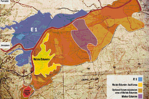
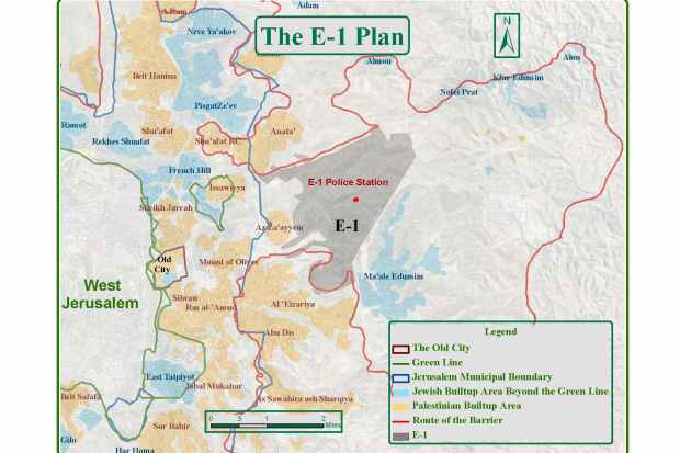
E1 (derived from “East 1”) is a term applied by the Ministry of Housing to an area located just east of the Jerusalem municipal boundary, on the hills between Ma’aleh Adummim and Jerusalem. It lies north of the Jerusalem-Ma’aleh Adummim road and edges the Palestinian towns of Anata, Abu Dis, Azariya and A-Zayim. E1, which covers some 12,000 dunams (12 sq. kilometers), is part of the planning area of Ma’aleh Adummim. The main artery between the northern and southern West Bank runs through E1.
In recent years, Israel has begun building and settling the area. The development plan for E1 includes the transfer of the West Bank (Judea & Samaria) Police Headquarters from its present location, and the construction of at least 3,500 residential units, a large commercial center, and more. Plans for the E1 area make no reference whatsoever to the local Palestinian population.
Construction in the E1 area commenced in 2004 under the direction of Housing Minister Efi Eitam. The work was illegal because no building permit had been issued. As a result of international pressure, construction was halted a short time after it began.
At the beginning of 2005, the Ma’aleh Adummim municipality approved two detailed urban plans for the development of the area, as mentioned above: one for approximately 3,500 housing units (apartment buildings and villas), and the second for the transfer of the police headquarters. The plan generated harsh criticism from the American government and the European Union. Both demanded that the plan be frozen, on the grounds that it violated Israel’s commitments according to the ‘Road Map.’ Instead, they maintained that the future of this territory be decided upon by a final status agreement between Israel and the Palestinians. Following this pressure, the Israeli government froze the project in 2004. However, building of the police headquarters was continued on the grounds that, like army bases, the police station would not be seen as creating facts on the ground, but rather as a building that could be removed.
On November 2012, following the Palestinian statehood bid, the Netanyahu government announced that it will promote a zoning plan for E1 which will allow the construction of 3000 housing units for Jews.
Here is the planned construction area for E1:
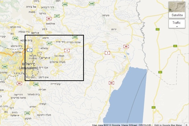
As can be seen in this regional map, construction at E1 will cut the West Bank in two (the area to the east is a desert, and on a very different altitude).
_______________
Ir Amim (“City of Nations” or “City of Peoples”) is an NGO which focuses on Jerusalem within the context of the Israeli-Palestinian conflict. Ir Amim seeks to render Jerusalem a more viable and equitable city for the Israelis and Palestinians who share it. The above text and the maps appear here with the permission of Ir Amim.


