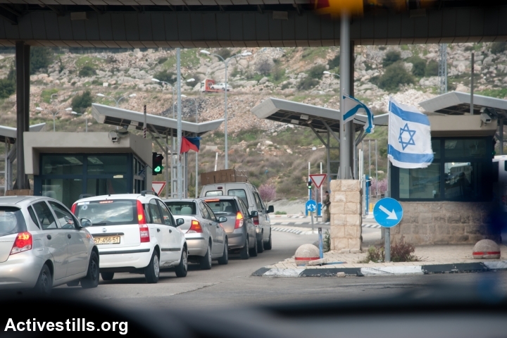
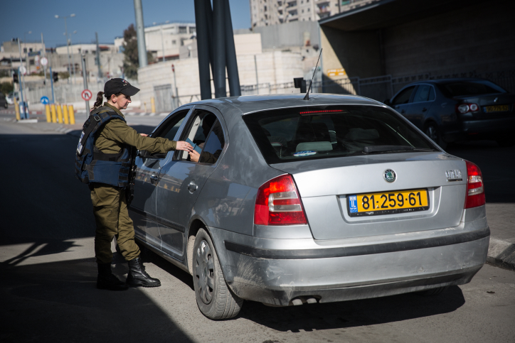
The very nomenclature of ’48 Palestinians and ’67 Palestinians shows how the Nakba remains at the root of Palestinian fragmentation. Roads function as a prime instrument of separation between the two.
By Amahl Bishara

Israeli policies preventing Palestinians from entering Israel and limiting Palestinian movement within the occupied territories have shaped Palestinian society, and the economy and politics in the West Bank and Gaza Strip for decades. What Israel terms “closure” is made material not only in checkpoints and roadblocks but also in the green license plates of cars registered to holders of Palestinian Authority identity cards (’67 Palestinians). However, less often explored are the implications of the fact that Palestinians with Israeli citizenship (’48 Palestinians) or East Jerusalem residency permits have access to yellow Israeli license plates, which allow them to move freely across much of Palestine-Israel, with the exception of the Gaza Strip.
As a ’48 Palestinian (albeit one born and living in the United States) with strong connections on both sides of the Green Line that divides the West Bank and Israel, I have been especially sensitive to movement across the Green Line. During many hours logged on the road, I have learned that driving is a site of embodied, everyday politics — the kind that is too often overlooked in favor of official or formal political statements and stances. The very nomenclature of ’48 Palestinians and ’67 Palestinians shows how the Nakba remains at the root of Palestinian fragmentation. Roads function as a prime instrument of separation between the two today.
Bethlehem to Al-Araqib: Reclaiming the landscape
On Land Day in 2011, I set out from the West Bank city of Bethlehem with two friends — a ’48 Palestinian activist I will call Bisan (all the names in this post have been altered) and a European photographer — to attend a rally in Al-Araqib. Al-Araqib is an unrecognized Bedouin village in Israel that has been destroyed by the authorities over 100 times; the state refuses to allow its residents to live there, despite their ongoing protest. And while Al-Araqib was an important place to hold a Land Day demonstration, I left Bethlehem with a certain sense of guilt. We were going into Israel despite the fact that almost everyone else we knew in Bethlehem was prohibited from doing so. As though to underscore the point, moments after effortlessly passing through a checkpoint with our yellow license plates, we traveled through three villages that, before the Nakba, had been home to the families of close friends who are now refugees in Bethlehem.
Given that Israeli authorities have repeatedly tried to physically erase it from the land, there are no signs pointing to Al-Araqib. We asked directions from an Arab man working at a gas station who told us to look for a dirt road beyond an intersection. We made the turn-off and persevered, but soon, on the crest of a hill on the dirt road, we were lost again. We ran into two Bedouin men in a pickup truck, who led the way until we could see buses and cars parked in the distance. Asking for directions was part of a Palestinian sociality that built connections and trust among Palestinians across differences of class and urban-rural difference. This was a practice that resisted Israel’s colonial politics of fragmentation and disorientation and cooperatively reconstituted the landscape.
Infographic: ‘Visualizing Occupation: Freedom of movement‘
After the Land Day rally wound down I followed Bisan back behind the large gathering, where some of the village’s families lived, despite the repeated demolition of their homes. A group of children were gathered around a van with Hebrew writing on its side. They showed us new kittens and eggs laid in a nest under the hood, along with mattresses stacked up in the back of the van. This was where they slept, they said, when they stayed in Al-Araqib. An apparatus of mobility — long disabled, it seemed — had been turned into a shelter of last resort for children displaced from their homes in this village.
We headed back to our car. The monochrome of the yellow plates — the absence of green Palestinian plates — stood out to me only because I move back and forth between Palestinian and Israeli areas. To those in Israel, it was simply the norm.
Bethlehem to the Galilee: Temporarily free from closure
For West Bank Palestinians, traversing the Green Line is far more fraught. In the summer of 2013, Jalila, a ’48 Palestinian living in the West Bank, made several journeys into Israel with ’67 Palestinians. All of these trips were illegal. In the following months, as the political situation deteriorated, not a single member of the group was willing to continue making these trips. Yet, for one summer, traveling from the West Bank to Israel became an experiment of the road networks connecting both sides of the Green Line.
First, Jalila and her West Bank friends strategized about how to smuggle the ’67 Palestinians into Israel. Their best option was to take the chance of driving a yellow-plated car through a checkpoint on one of the many bypass roads that service Israeli settlements and circumvent and fragment Palestinian communities (green-plated cars are often barred from bypass roads). Although the checkpoint is visible from the hillside road regularly used by Palestinians, it remains off limits to them. Once Jalila and her friends began talking about the possibility of crossing, her friends began paying more attention to the checkpoint, observing: “They don’t stop every car!”
Later, when they actually passed through the checkpoint, they took a roundabout route to make it harder for the soldiers to discern that they were coming from a Palestinian area, as opposed to nearby settlements. Jalila wondered if Israeli authorities had set up cameras to monitor who took this extra loop — a simple indicator of those trying to avoid detection.
Despite detailed documentation of the system of closure, there are limits to how much Palestinians can know about the system that constrains them. By comparison, Palestinians often assume that Israeli officials have many ways of knowing everything they wanted to know about Palestinians. When I asked a West Bank human rights lawyer whether, in writing about these journeys, I should avoid discussing the smuggling strategy of Jalila and her friends, he told me it did not matter — surely, if the Israelis were concerned with this back route, they already knew.
Jalila and her friends did not look up the penalties for crossing illegally or for smuggling someone into Israel. They knew from other people’s experiences that they were arbitrarily applied. The first time someone is caught inside the country illegally, Israeli Border Police might simply return the person to the West Bank. Detention or interrogation might precede being sent back, and the detainee would likely be forced to sign a piece of paper saying that next time they will face a fine. It is also known that Israeli soldiers can take the matter of penalties into their own hands, sometimes even going so far as to detain or beat Palestinians (soldiers are rarely held responsible for these abuses).
Often, Jalila and her friends were surprised by how little attention the soldiers at the checkpoint were paying: “If we’d come through with green [Palestinian] license plates, he would not have noticed!” Another time, soldiers stopped the car in front of theirs. Jalila remarked, “We were lucky this time.” Her companion retorted, “No, we weren’t lucky — the people in the car in front of us came directly from the city, and changed lanes at the last moment to appear as if they had not. Plus, one was wearing hijab.” His vehemence belied the basic fact that they were lucky each time they passed safely. This was knowledge gained by the skin of one’s teeth, uncomfortably and in fear.

Still, that fear was at least partially assuaged by the delight of having broken through. Not only did passengers feel temporarily free from years of closure and restrictions but, in addition, passing through the checkpoint without being inspected seemed to debunk the myth that closure is about Israeli security as opposed to dividing and oppressing Palestinians.
On the roads inside Israel, West Bank Palestinians continued their analysis of the territory. From Highway 6, the newest north-south highway in Israel, attentive passengers can see the West Bank city of Qalqilya from behind the separation wall. Speeding by, a West Bank passenger commented, “It would take twice as long to get to Qalqilya from Bethlehem in the West Bank, because the roads are so much less direct and are badly maintained.” In contrast to Israeli infrastructure, the Palestinians analyzed the de-development of their own roads.
Although Israeli soldiers sometimes check cars re-entering the West Bank via the main terminals on the edges of Palestinian cities, they almost never stop cars re-entering via checkpoints used by both settlers and Palestinians. Still, return trips to Palestinian areas of the West Bank were jarring for Jalila and her companions, switching from fast, open roads onto luridly circuitous ones. They also experienced the faint shame of return, a kind of payback for the joy of leaving. Even though Jalila and her companions were taking risks to illegally enter Israel, doing so felt like a betrayal of those who had not been invited.
Separation, not security
Geographic fracture has been one of the prevailing forces in Palestinian politics since 1948. Israel’s system of closure divides Palestinian citizens of Israel from Palestinians of the 1967 territories and clearly affords Palestinian citizens of Israel more rights. Yet, examining how these groups actually move suggests important similarities in their circumstances. Both groups relate as subalterns to the Israeli state and to the road infrastructure — one of the state’s most common manifestations.
For both Palestinian citizens of Israel and Palestinians of the West Bank, journeys lead to political analyses, explicitly stated or implicitly inserted into jokes or offhand comments. In crossing the Green Line without being stopped, both groups gained the sense that Israel’s security strategies are more effective at perpetuating a logic of separation and racist demonization of Palestinians than actually preventing Palestinians from the West Bank from entering Israel. Our Palestinian connections to place are forged through anxious, angry, and urgent forms of political knowledge, because the places themselves are the result of a colonial process.
Amahl A. Bishara is an associate professor of anthropology at Tufts University. She is the author of Back Stories: U.S. News Production and Palestinian Politics (Stanford University Press, 2013), and the director of the documentaries Degrees of Incarceration (2010) and Take My Pictures For Me (2016, with Mohammad Al-Azza).
A version of this article was originally published on The Nakba Files, part of The Nakba & the Law, a joint project of the Columbia University Center for Palestine Studies and Adalah – The Legal Center for Arab Minority Rights in Israel. The article is an edited excerpt of “Driving while Palestinian in Israel and the West Bank: The politics of disorientation and the routes of a subaltern knowledge,” American Ethnologist 42(1), February 2015, pp. 33-54.
