

It came as a surprise. I didn’t really intend to rebel against the newly legislated “Nakba” (“disaster”) law until Independence day. After all, the law refers specifically to that occasion. It states that any organization that uses Independence day to commemorate the enormous loss suffered by the Palestinain people in 1948-1949, will be penalized by the state.
Israeli independence day, which is also the Nakba memorial day, is still two months or so away, but the law passed this week, and that might have inspired my uncontrolled, nocturnal rebellion. Yes, your honor, I dreamt of the Nakba last night. There was no way I could help it.
In my dream I was sent to the Sea of Galilee to compose a tourism article for some magazine’s Passover edition. Such domestic tourism pieces are always a challenge. This country is the size of New Jersey on a good day, and yet is affluent enough to produce a vast readership hungry for take-the-kids-on-a-short-hike-through-this-little-known-valley-then-visit-this-secret-little-winery kind of texts. It’s been so overcombed by tourism journalists that little is left to discover.
The only new things I find on my dream expedition happen to be old and partially destroyed. They are ruins of villages, towns and actual cities. In the southern Golan Heights, for example, I come by the ruin of a massive church, its dome, decorated with gorgeous blue mosaics, still intact.
This is clearly a reflection of an actual church in the same region: one of the only structures that remained erect after the village of Banias was destroyed in the war of 1967. While some progress was made in educating Israelis about the damage done in 1948, the destruction that took place in the Golan Heights following the Six Day War is still mostly taboo. From what information I have, more than 130,000 Syrian dwellers of the region became refugees and many villages were destroyed.
In my dream I return to my hotel in Tiberias, determined to write not a recreational article but one that describes what I’ve seen. In the city I meet an American archeologist. She leads me to the ruins of an entire town, completely engulfed by the suburbs of Israeli Tiberias.
Throughout my childhood I’ve come across such ruins all over the country. Having grown up on Biblical stories and tales of the heroic Maccabees, I assumed as a child that they were “ancient”, related to pre-Helenist and Helenist times. Only later in life did I grasp that many of them were inhabited at a time in which my grandparents were already married.
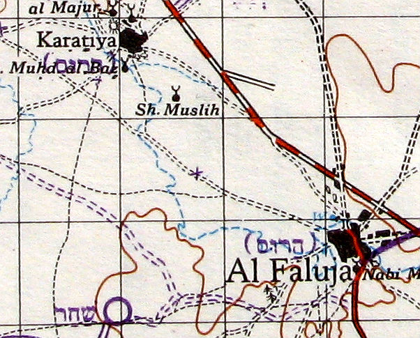
I am grateful to the Knesset for inspiring this dream, but I don’t give it full credit. A certain actual discovery also played a part here. A few weeks ago a gentleman passed away in the neighborhood and his books were put out on the street, as part of a lovely Tel-Aviv tradition which allows random book-lovers to inherit what treasures they find.
Among the books my friends and I discovered a collection of maps. They present the country at a 1:100,000 scale and while published in the mid 50s, are mostly based on British maps charted in the early 40s.
The publishers of the maps simply published the British maps, adding a circle for each new Israeli settlement founded over the years and marked each wrecked Palestinian village with the word “demolished”. I never had any idea how large those communities were and how numerous. An excerpt of one such map is provided above. The entire compendium is literally the stuff of nightmares.