

Gori will forever remain in my memory, like an image from some strange dream. I don’t necessarily mean a bad dream, there’s something very delightfully bewitching about this city, as there is about everywhere in Georgia, but it’s spooky nonetheless, especially on a cold winter’s day.
Gori is famously spooky for being Stalin’s hometown and featuring both a statue of the man and a shrine-like museum dedicated to his life, but the spookiness begins already in the suburbs. They are treeless, streetless, made up of thousands of cookie-cutter abodes set in exact rows. These are no suburbs. These are refugee camps set up for ethnic Georgians who left South Ossetia during the 2008 war. Amazingly, they don’t even look new, as if nothing in Gori can look new by municipal law.
Actually, one thing does look new in the city. Ironically, that happens to be the ancient hilltop fortress, dating back to the 4th century BC. Its walls are wonderfully preserved. The overlook an old town made of graying houses and one of the most ramshackle markets I ever visited.
Gori’s market offers great local cheese and delightful candy made of reduced grape juice and nuts, but to get to such goods one must hop over puddles deep as the ankle and the occasional sleeping drunkard. Across the river appear some dour-looking commie-blocks. Ladas honk their way along the embankment, factory smoke obscures the distant silhouette of the snow-capped High Caucasus.
A passage to Ajaria
Gori’s sadness gives a clue as to the war’s cause. Georgia is finding it difficult to develop and reach its full potential, partially due to political and economic embargos placed by an enormous neighbor and long-time occupier. Supporting “separatist regions” (in truth mostly the leaders of these regions, who wish to draw political capital) is one way Russia “trips” Georgia. This is what I gathered from visits to both countries shortly following the war, and I’ll be hard pressed to change my mind.
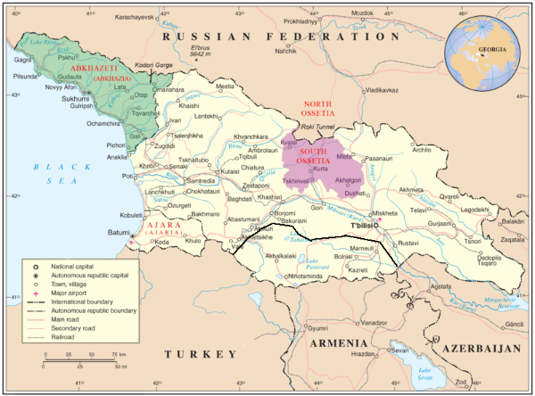
Whether declaring war in response to such provocations, as president Saakashvili did in 2008, is a good idea or not, Georgia is certainly being tripped over and over, and the state of its sidewalks serves only as one symptom to this. A look at the map provides three others. All are lines.
On my map, a dark, unyielding red line now separates South Ossetia from the rest of the country. It runs a mere ten kilometers or so north of Gori. Another line and the reminder of another war runs in the west, marking the boundary with Abkhazia. Just like the Ossetian boundary, it is red and barbed with black dots. The Russian Federation recognizes Abkhazia as a sovereign state, and maintains autocratic rule there.
A slightly milder line surrounds the region of Batumi, on the southwestern Black sea coast. The case of separatist Ajaria has not been successfully decided by Moscow (though God know it tried) and since 2005, with the escape of its leader Asian Abshidze, it is accessible from the rest of Georgia.
These lines are not taken for international borders by the map’s charters. Other countries appear in mundane yellow, very different from Georgia’s topographic browns and greens. Only the most basic roads and town appear in the map’s Armenia, Azerbaijan, Turkey and Russia. Abkhazia and Ossetia are still Georgian on this map.
How Georgian are they in real life? I asked a local friend, Maya, what would happen to her if she drove to one of the red lines. “They probably won’t kill me right there at the checkpoint, but they’ll certainly arrest me,” was her reply.
Walk the line
Why am I so interested in these lines? It’s because I’m an Israeli, and Israelis compare everywhere to their home. Analogies in this case may be drawn from various perspectives. Take Gori’s refugee camps. They can be likened to Palestinian refugee camps which turned into historical geographic and sociological facts, solid as cities. Alternately, they remind the eye of the special compound created outside Ashdod, for settlers who were expelled from the Gaza strip during the “Disengagement.”
Take Georgia’s vulnerability. It will remind Palestinians of their nation’s position facing the occupation, while Israelis will see in it their position in regards to the Arab world. In our eyes the “Arab world” is a solid, threatening entity, not unlike the Russian bear. Ethnic groups within Israel that relate to that Arab world may be likened by some to the Ossetians and Abkhazians.
I would disagree with such a comparison, but one common denominator we have with the Georgians can’t be denied. It’s those lines, of course. Yes, the green line always appears faded on our maps, if it appears at all (until the 1990s, printing maps in which it appears was illegal in Israel), but it’s a similar kind of line. The checkpoints are there, the soldiers are there, the threat of being arrested is there.
As with the Georgian map, Israeli and Palestinian maps commonly present the entire land as a monolithic entity, with or without a line running through it. The two situations are insane and unhealthy. If the Georgian lines seems at the moment a tad more difficult, despite the lack of fences running along them, if Gori looks more deprived than all Israeli cities and most Palestinian ones, if the lines are darker and scarier on Georgia’s maps then on ours and the threat greater for those venturing to cross (except in the case of Gaza), this should only serve us as a warning: that we must do everything in our power to continue and seek a true solution, that we must do everything in our power to avoid another war, even if we do want for the lines to be more clearly drawn.